
How to find us
Enlarge map | Press [-] to zoom out
Our Address
Industriestraße 14
48308 Senden
Germany
Telephone +49 (0) 2597 239
The reception closes at 8.00 pm. Please be here in time!
Our Geolocation
N51° 50' 42.167"
E7° 28' 18.959"
51.8450463
7.4719331
Directions
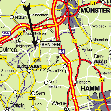
By car
- A43 Münster - Wuppertal
- Exit Senden, B 235 towards Lüdinghausen
- in Senden cross the canal bridge, turn to the right ~ 500m after the bridge (see camping sign)
- after approximately 1km turn right at KranenCamp sign
oder
- A1 Münster - Dortmund
- Exit Ascheberg, towards Ottmarsbocholt/Senden
- B235 towards Lüdinghausen
- Camping sign on the right hand side: turn right
- after approximately 1km turn right at KranenCamp sign
By bike
- our site is on the flagged "100-Schlösser-Route" (100-Castles-Trail) between Senden and Lüdinghausen, ~ 1,5 km south of Senden centre
- also on the flagged "Route Dortmund-Ems-Kanal"
- the "Deutsche Fußball-Route" (German Soccer-Trail) is about 2km away
By boat
- Dortmund-Ems-Canal km 46,6
- approaching from the south turn to starboard right before the Senden Gate, coming from the north turn to the port side after the Gate to the "Alte Fahrt" (the old canal) at km 47
- Our marina is on the port side at km 46,6
By public transport
- Senden-Bösensell Station is about 7 km away and on the lines RE2 (Münster-Düsseldorf) and RB42 (Münster-Essen)
- The local bus stop is called "Senden Industriestraße" and about 1 km outside of our camping. You can go there by Schnellbus (fast bus) S90/S92 (Münster-Autobahn-Lüdinghausen, Journey Planner)

